Account Login/Registration

Access KamloopsBCNow using your Facebook account, or by entering your information below.


Facebook


OR


Register

Privacy Policy

Last snowpack report of the year shows elevated drought hazards across BC

Similar to the June 1 Snow Survey and Water Supply Bulletin, the final bulletin of the year is pointing to another summer of elevated drought hazards across BC.

The latest bulletin, which used data collected on June 15, says that typically three-quarters of the annual snowmelt has melted by now.

This year’s snowpack melted earlier than normal and about 90% of it gone.

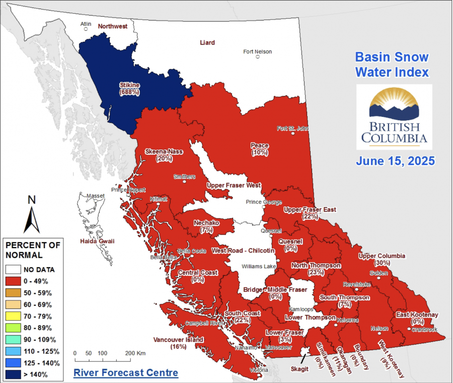
According to the data, the provincial snowpack level is sitting at 13% of normal levels, or 87% below normal. That is a sharp drop from the 44% of normal reported at the beginning of the month.

Last year, the provincial snowpack was averaging 38% of normal levels by June 15.

This year’s snowpack is only nine points above the average recorded on June 15, 2023.

<who> Photo Credit: BC River Forecast Centre

According to the bulletin, most of BC recorded the warmest temperatures of the year so far and rapidly melted the remaining high elevation snow. However, weather forecasts for the next week are bringing unsettled conditions and potentially heavy rainfall to some areas.

The bulletin adds that snowmelt-related-related flooding risk remains low and any potential flooding will be caused by widespread and heavy rainfall events, which are possible throughout the Interior.

Snowpack levels across the Southern Interior have dropped drastically since June 1.

The Okanagan is sitting at 11% of normal, which is down from 44% reported earlier this month.

A bit further north, there was once again insufficient data collected for the Lower Thompson basin, which includes Kamloops and Merritt.

The North Thompson is at 23% of normal, down from 65%, and the South Thompson, which includes the Shuswap, dropped from 53% down to just 7% of normal levels.

Several snow basins across the province, including the Middle Fraser, Quesnel, East Kootenay, Boundary, Similkameen and Central Coast, are all recorded 0% of normal levels.

<who> Photo Credit: Province of BC </who> Undated file picture of the Fraser River near Spences Bridge.

Six snow basins had insufficient data to calculate any percentages.

The only snow basin sitting above normal is in the Stikine, which is sitting at a whopping 688% of normal levels for the middle of June.

“Moving into the summer, drought hazards are elevated due to long-term precipitation deficits, low snowpack, early snowmelt, and an increased likelihood of warmer than normal and drier summer weather,” the final snow bulletin concluded.

“Weather will continue to play an important role in the summer drought conditions.”

As of June 19, the BC Drought Portal is showing that 28% of the province is at drought level one while 43% of the province is at drought level two, which means that adverse impacts to socio-economic or ecosystem values are unlikely, but water users should still be mindful of water conservation.

Nearly one quarter of the province is sitting at drought level three while only one basin (the Elk-Flathead Valleys) is at drought level four.


Send your comments, news tips, typos, letter to the editor, photos and videos to [email protected].


weather-icon
Sat
21℃

weather-icon
Sun
25℃

weather-icon
Mon
26℃

weather-icon
Tue
29℃

weather-icon
Wed
26℃

weather-icon
Thu
24℃
current feed webcam icon

Top Stories

Follow Us

Follow us on Instagram Follow us on Twitter Like us on Facebook Follow us on Linkedin
Follow Our Newsletter
Privacy Policy