(UPDATE: May 18 @ 1:00 pm) – A forecast of wet snow conditions on some BC Interior highways has led to multiple weather statements being placed for Monday morning.
The affected areas include the Okanagan Connector (Merritt to Kelowna), Hwy 3 (Paulson Summit to Kootenay Pass), Coquihalla Highway (Hope to Merritt and Merritt to Kamloops), and Hwy 3 (Princeton via Allison Pass).
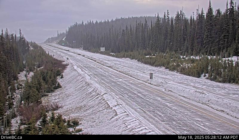
“A Pacific front will approach the southwestern BC Interior Monday morning,” stated Environment Canada.
“Wet snow is expected over the highway summits as snow levels will be near 1200 metres initially. Snowfall accumulations from trace to (five centimetres) are expected on Monday. As snow level rises to above the summits Monday afternoon, snow will then change to rain.”
While the wet snow is not expected to impact a majority of the highways until Monday, the Kootenay Pass is expected to receive some snowfall today and potentially through to Tuesday morning
Up-to-date road conditions can be found online at this link.
(Original story: May 17 @ 3:40 pm) – May long weekend commuters are being warned to be prepared after Environment Canada issued special weather statements for a handful of BC Interior highways.
The affected areas include the Okanagan Connector (Merritt to Kelowna), Hwy 3 (Paulson Summit to Kootenay Pass), Coquihalla Highway (Hope to Merritt and Merritt to Kamloops), and Hwy 3 (Princeton via Allison Pass).
According to Environment Canada, the special weather statements were issued because of the potential for wet flurries overnight and into Sunday morning.
“Please be prepared to adjust your driving as weather conditions at high elevations may change quickly,” reads the warning.
“Slow down and maintain a safe following distance.”
Environment Canada added that the reason for the wet flurries is an upper disturbance passing through the BC Interior and lowering the snow levels to 1500 metres overnight.
“Snowfall accumulations will be minimal, from trace to (five centimetres),” added the agency.
“Rising temperatures on Sunday will melt away the snow.”
Up-to-date road conditions can be found online at this link.


