Account Login/Registration

Access KamloopsBCNow using your Facebook account, or by entering your information below.


Facebook


OR


Register

Privacy Policy

UPDATE: BCWS responding to 220-hectare wildfire in the Shuswap

(UPDATE: July 22 @ 11:15 am) – The BC Wildfire Service map shows a half dozen wildfires started by lightning last week are either under control or being held.

A fire burning near Seymour Arm, dubbed the Lower Blueberry Creek fire, has been classed as under control and did not grow past one hectare.

On July 18, the Columbia-Shuswap Regional District (CSRD) said all but one of those fires was larger than one hectare, which was the Mara Mountain wildfire.

It is now the single largest wildfire burning in the Shuswap region.

CSRD officials said they were notified late Sunday evening that the fire had grown to 220 hectares, but it was not moving towards Sicamous or Swansea Point.

“The fire is currently 500m above the Aston Mara East Forest Service Road. This FSR is between the fire and any populated areas,” the CSRD says.

“BC Wildfire is still confident that fire behaviour will decrease if it reaches the 2021 Two Mile wildfire burn scar.”

There are currently no evacuation orders or alerts for any of these wildfires.


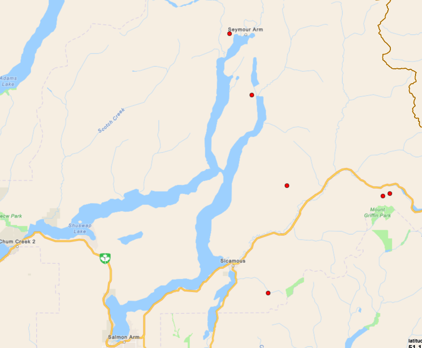
(Original story: July 18 @ 1:30 pm) – Six new wildfires have sparked in the Shuswap region.

According to the Columbia-Shuswap Regional District (CSRD), the fires are burning in the Seymour Arm, Queest, Mara Mountain and Mount Griffin areas.

All are suspected to be caused by lighting.

According to the BC Wildfire Service (BCWS), there is no immediate threat to structures and air tankers are being used to drop fire retardant in the Seymour Arm area.

All but one of the fires is under one hectare. A fire southeast of Sicamous is currently estimated at five hectares.

“A helicopter with rappel crew has assessed four fires in the Sicamous, Malakwa and Three Valley Gap areas,” says the CSRD in an update to residents.

“The only one larger than one hectare is Mara Mountain, which is mapping at five hectares burning in steep, high-elevation terrain.”

The Shuswap Emergency program has activated an Emergency Operations Centre in response to the fires.

Overnight, several lightning strikes were recorded and more fires may start as a result.

<who> Photo Credit: BCWS </who> Map of the six new wildfire starts in the Shuswap as of Thursday, July 18 at 12:30 pm.


Send your comments, news tips, typos, letter to the editor, photos and videos to [email protected].


weather-icon
Fri
12℃

weather-icon
Sat
10℃

weather-icon
Sun
15℃

weather-icon
Mon
14℃

weather-icon
Tue
16℃

weather-icon
Wed
16℃
current feed webcam icon

Top Stories

Our Latest In Focus

Follow Us

Follow us on Instagram Follow us on Twitter Like us on Facebook Follow us on Linkedin
Follow Our Newsletter
Privacy Policy